Monday, March 30, 2015

Drydaho and return to Ewok village.

We didn't leave Fairbanks for Hawaii or some other tropical locale this winter. Thus, Molly and I decided that we ought to head back to the lower 48 for a second round of backcountry skiing at the Bench Hut in Idaho's Sawtooth Range, in what is evidently becoming an annual tradition planned by friends and frequent ski partners Casey and Helena.

After dropping off the dog, we took the red-eye out of Fairbanks.  Earth was in the midst of a magnetic storm, and the views of the Aurora out the plane windows was very unusual (more unusual was that they were in the southern sky).  12 hours later, we were in a sunny, snow-free Missoula; the snow line on the mountains was similar to mid-May of the previous year, and temperatures were in the high 60s.  Spring break!

We spent two days in Missoula visiting friends and packing for the trip to the Sawteeth (also climbing in Kootenai) before making the drive to an also snow-free Stanley, where we ate prime rib at the Mountain Village Cafe.

The skin to Bench Hut typically begins with two miles of flat on a closed road between the highway and Redfish Lake.  The morning of, we found that the road had mostly melted out, while remaining technically closed (or so stated the flimsy plastic sign planted in the middle of the ungated, two-lane, paved superhighway.  It would be a long and morale crushing affair to deal with skinning on asphalt at this time of morning, so we (were forced to redact our blog entries).

The remaining journey from Redfish Lake to the hut was straightforward, if a little bare in spots, but we made good time to the hut, reaching it by noon.  With sunny skies, but with a storm forecast for that night, Casey and I left immediately to pursue our primary objective of the trip, Mt. Heyburn, in good stability and weather, setting out from the hut just before 2PM.

Heyburn occupies the head of a large cirque, and has two summits which are split by the iconic north-facing Petzoldt couloir.  Unfortunately, to attain the higher western summit via the couloir involves either aid or a pitch of 5.11 (neither of which I am capable of), both on terrible rock.  Thus, we elected to circumvent this more direct, but less ideal route, in favor of the Stur Chimney on the peak's western flank.

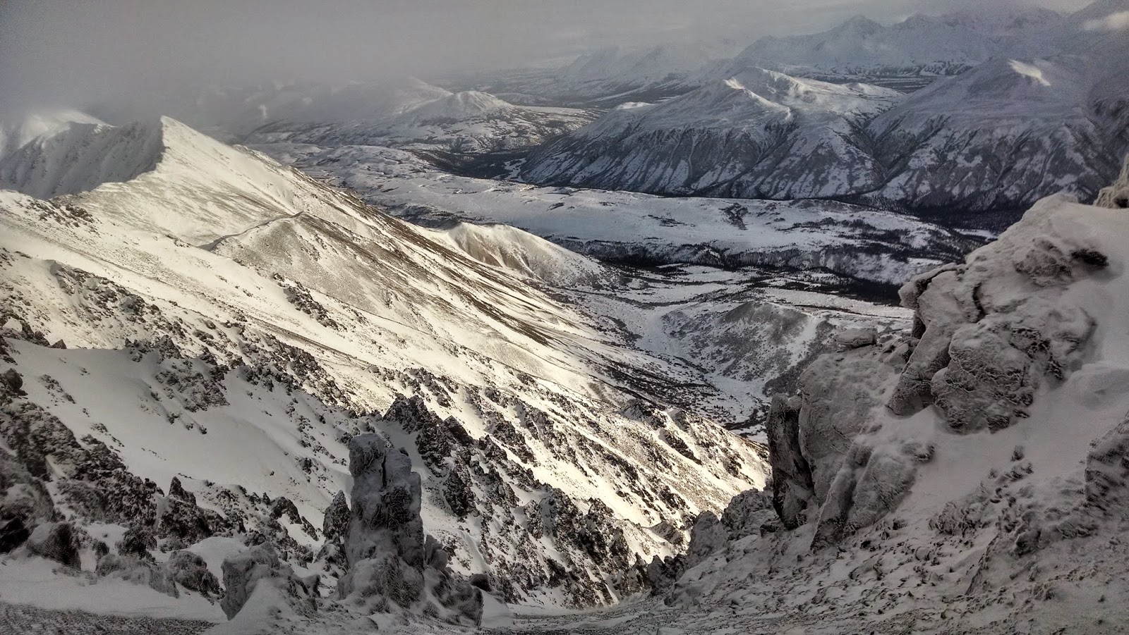
View from belay 2 in the Stur Chimney.

We reached the base of the technical portion of the chimney at around 4.  The chimney itself was bare, but the 4th and low-5th class slabs constituting the approach still held snow in gullies, and after ditching our snowboards, climbed a steep snow gully for a hundred or so feet before it petered out into a sketchy descending traverse along a snowy sloping ledge bisecting steep granite slabs.  After carefully navigating the traverse, we roped up for our first pitch of climbing, a short 5.2 step to reach the base of the Stur Chimney proper, which we climbed in snowboard boots.  Here, we transitioned to climbing shoes for the two pitches to the summit.  The chimney was snow free, but felt somewhat more difficult than the 5.2 advertised in at least one guidebook.  5.5 or 5.6 would probably be more accurate.  In any case, the going was easy, and we soon reached the summit of 10,299' Mt. Heyburn.  As always, we spent little time on the summit.  Having only a 50m rope, we ended up making five rappels off of tat-shrouded bolts, a large chockstone, two aging pitons, a horn, and a small tree, respectively, to reach our snowboards.  The egress back to the hut went quickly, and we arrived just before dark for a hut to hut time of 6 hours.


Summit anchor nest.

Heyburn summit block.
 That night, it snowed 6 inches, leaving pretty nice dust on crust conditions.  The next day, we (being a group of eight at this point) skied a beautiful hanging snowfield on a large fin above the gunbarrel couloir into perfect mellow glades.  The group split, as most folks went to ski the gunbarrel, and Molly and I went to check out the upper reaches of the next glade to the east. 


The wind picked up and the snow intensified into the evening.  By the next morning, there were 18 inches of wind deposited snow on lee slopes, prompting vigorous and spooky sluffs that were just on the verge of being soft slabs.  We skied carefully, and with the snow still coming down, stuck to relatively mellow lines.  Casey and I managed to make a foray up to Fishhook point, Heyburn's lower cirque-mate, but got only marginal views through the storm (though an  excellent descent).


Concerning wind slabs below the Petzoldt Couloir.
By the next day, the wind and snow had abated, but had left behind full-on deep and noisy wind slabs, slamming the door on the possibility of ambitous lines or far-afield tours.  Thus, we climbed Fishhook point once again, admiring the tracks of one seriously hard-assed mountain goat, and generally enjoying the nice views of the high peaks of the Sawtooths.


Fishhook Pt. (Dave Dog Peak) summit ridge.

Billy the goat leaves his mark.


The next day we headed back to Missoula.  I spent another few days climbing at Mill Creek, and went on a nice bowl-bouncing tour up Camas Peak in the central Bitterroots, before flying back to Fairbanks, just in time to catch the tail end of the meltdown.  Where did all the snow go?

Tracks on the unnamed high point behind Camas Peak.

Harscheising back to Camas proper.


Spring ski races

Over the last month, I've had the opportunity to take part in two races put on by Endurance North.

The first was the Chena River to Ridge, a 45 mile loop linking the Compeau and Stiles Creek trails, starting at mile 32 on the Chena Hot Springs Road.  The 25 mile Compeau trail is graded very moderately the entire way, and the excellent grooming by the race organizers made it even better.  The Stiles Creek trail is a little bit rougher, with quite a bit more ups and downs on the ridgelines, but was also very well groomed.  I went out moderately, kept a fairly casual pace the whole way, and generally had an uneventful race.  I finished in around eight and a half hours, for second place in the ski division (the field was pretty small).

Overflow on the Compeau Trail from a pre-race scouting trip.

Louie is skeptical of snow machines.

Near the top of the Compeau trail.

Switchbacks near Twin Bears.
Two weeks later, I skied the Tanana River Challenge, which was unfortunately foreshortened from 45 miles to 32, as a result of sub-zero temperatures at river level.  The shortened TRC course followed the Tanana downstream for 6 miles, followed by a really pretty 20 mile loop through the forest, and back up the river to the start.  I had intended to skate this race, but cold temperatures caused me to shy towards classic gear, a choice I somewhat regret; skating on the river, followed by kicker skins in the tighter sections of forest would have been ideal.  As it was, I hardly needed to wax my classic skis, applying only a layer of ironed-on base binder, followed by a layer of ironed-on Toko X-cold.  Any more wax would have been excessive.

I tried to push much harder at the Tanana River Challenge, partly due to the easier course, and partly due to the larger field of skiers.  Throughout the race, I oscillated between third, fourth, and fifth place, but eventually got beat out by the skaters on the final 6 miles back up the river, for a fifth place finish in 5:28, about half an hour behind the winner.  It was a slow day for skiing.  I'm confident that with skate skis and faster conditions, I could decrease that time by well over an hour. Already looking forward to next year.


Monday, March 2, 2015

Ode to Sunshine

On Friday, Jenna and I decided to take advantage of the calm winds, sunshine, and 20 degree temperatures to break for the Delta Range.  Our intent was to ski the south aspect from the ridge splitting the Castner Glacier to the north and the Fels Glacier to the south.

A frozen Lower Miller Creek.

We left Fairbanks at 7, negotiating sheet ice plastered on the Richardson by our recent freezing rain storm.  We reached Lower Miller Creek around 10, and were on our way by 10:30.  The big outwash plain of Lower Miller was a bit windy, but firm and fast going.  After a few miles of skinning, we made it to a point where the creek flows out of the mountains into the big Delta valley, and began to climb through a reasonably spacious alder thicket, following a wayward moose who seemed to have a good idea of the most efficient way through the bushes.
 
Engaging the brush.

Escaping the brush.

 The nice thing about interior AK is that the brush peters out quickly, and we were soon skinning up moderate slopes on a supportable wind crust.  Views out to the enormous Mounts Moffit, Shand, and McGuinness were characteristically imposing, and I was reminded of how much I'd like to get back amongst those mountains again.  We made short work of the remaining climb to the ridgeline, and were greeted with views of Silvertip and White Princess among other smaller Delta peaks.

13k+ Mt. Moffit dominates the Hayes Range skyline on the other side of the Deltana.

Lunch spots.

Ridgeline cruising.

Travel on the ridge was fast, and we followed Wolverine tracks for about a thousand more vertical before reaching a point where a fall line run would place us directly at the Fels terminus.  Dropping into the vast glade, we expected to find wind blown, slabby snow or sastrugi like we had been climbing on.  Rather, we found deep and settled powder snow, and took turns trading tracks for over a horizontal mile and 3000 vertical feet.  From the bottom of the run, it was a quick schuss out the bottom of Lower Miller Creek, and we were back to the car with plenty of daylight remaining.


This is not a black and white photo, there just aren't any plants.

See?

Looking back up the egress route.


Sunday, March 1, 2015

A first shot at Alaska mountaineering in Panorama Mountain's south couloir.

I haven't done much in the way of posting on this blog since moving to Alaska.  Fall was busy and I managed to blow a knee running the Pinnell Mountain Trail (one of the interior's best) in September, putting a damper on many of my autumn plans.  By the time my knee had satisfactorily recovered it was wintertime, and the days were mostly too short for photographs or for trips out of town.  I went skate skiing alot, and generally tried to maintain fitness for springtime.

Now the days are getting long again, temperatures are moderating, and the snowpack has (actually had, since it's nuking snow this week) stabilized.  On February 15th, I joined Marc, Joanna, Jenna, and Alex for an attempt on the south couloir of Panorama Peak, immediately to the east of the George Parks highway, and a few miles south of Denali's front gate.

Twas the obvious one to the
Alaska has the tendency to be much larger than it looks in distances and elevations, and Panorama exemplifies this trait.  Having looked at a fair share of couloirs I feel as though I can accurately assess their length from below.  I would have pegged this one at around 2000'.  It turned out to be more than 3000', with a sustained pitch of around 40 degrees.  The snow was good for cramponing: occasionally a bit hard, soft, or thin, but generally firm and secure.  It was mostly a bit of windblown powder sitting atop classic interior depth hoar.  The booger sugar is ubiquitous here, I'm coming to learn (which is something to get used to, I guess). 
 
Midway break.
We made consistent progress up.  The weather was breezy and skies overcast.  There were two exposed scree bands, which would have stymied an unbroken ski run.  Otherwise, I was wishing desperately that I had brought snowboard. 
Wine, cheese, wind.
The top of the couloir is not the top of Panorama Mountain, but as we reached the summit ridge, the high winds that we had heretofore been protected from, combined with the late hour conspired to content ourselves with the climb, rather than a new summit.  We drank a little bit of wine, and ate a little bit of good Swiss cheese (thanks Marc), and began the downclimb.  I realized at this point that I had not really downclimbed steep snow before (having always just snowboarded), and it took a minute to find the appropriate rhythm. 

Looking over the south face of Panorama Mountain.

Traversing over some rocks.
After the steep head of the couloir, the descent was easy, and we swiftly and safely reached the bottom, just in time for self-arrest practice and recreational glissading.